
🌺 Where Is Hawaii Situated? Location, Geography & Facts
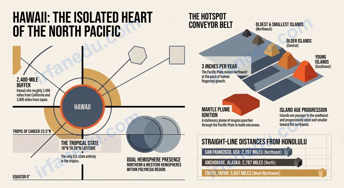
Have you ever looked at a world map and wondered: where exactly is Hawaii? It floats in a vast blue expanse, seemingly in the middle of nowhere. That isolation is not an accident — it is the direct result of one of Earth’s most dramatic geological processes.
Hawaii is situated in the central North Pacific Ocean, roughly 2,400 miles (3,860 km) southwest of California. It is the only U.S. state located entirely outside North America and entirely within the tropics. The archipelago spans about 1,500 miles from northwest to southeast, with its main islands clustered at the southeastern end.
- 🗺 Understand Hawaii’s precise geographic coordinates
- 🏝 Learn how the island chain formed and why it sits where it does
- 📏 Know the real distances between Hawaii and major world cities
- 🌡 See how location directly controls Hawaii’s tropical climate
- ✅ Correct the most common student misconceptions about Hawaii’s position
Hawaii is situated in the central North Pacific Ocean, approximately 2,400 miles (3,860 km) southwest of California and about 3,900 miles (6,275 km) from Japan. Its geographic coordinates range from roughly 18°N to 28°N latitude and 154°W to 179°W longitude. It is the only U.S. state located entirely outside North America and in the tropics.
⚡ TL;DR – Quick Summary
- 🌊 Hawaii sits in the central North Pacific Ocean, ~2,400 miles from California.
- 📍 Coordinates: roughly 18°N–28°N latitude, 154°W–179°W longitude.
- 🏝 137 islands total; 8 main islands in a northwest-to-southeast arc.
- 🌋 Formed by a volcanic hotspot beneath the Pacific Plate — not plate collision.
- 🌡 Tropical climate year-round because it sits just below the Tropic of Cancer.
- 🇺🇸 50th and most recent U.S. state (admitted 1959), geographically in Polynesia.
| Fact | Detail |
|---|---|
| Ocean | North Pacific Ocean (central Pacific) |
| Nearest continent | North America (~2,400 mi / 3,860 km) |
| Coordinates (Honolulu) | 21.3°N, 157.8°W |
| Total islands | 137 islands, islets, and atolls |
| Main islands | 8 (Hawaii, Maui, Oahu, Kauai, Molokai, Lanai, Niihau, Kahoolawe) |
| Archipelago length | ~1,500 miles (2,400 km) NW to SE |
| U.S. state since | August 21, 1959 (50th state) |
| Capital city | Honolulu (on Oahu) |
| Time zone | Hawaii-Aleutian Standard Time (UTC−10) |
| Geographic region | Polynesia, Oceania |
🗺 How to Find Hawaii on a Map (Step-by-Step)
Finding Hawaii on a world map is easy once you know the two-coordinate trick. Start with the Pacific Ocean and work inward using latitude and longitude — you will land on the islands in under a minute.
- Open any world map and locate the Pacific Ocean — the largest ocean on Earth, stretching between the Americas to the east and Asia/Australia to the west.
- Find the center of the Pacific — Hawaii sits roughly in the middle, slightly closer to the North American side than to Asia.
- Trace the 20°N latitude line westward from Mexico. Hawaii’s main islands cluster just below the Tropic of Cancer, near this line.
- Find the 157°W longitude line — Honolulu, the capital, sits at approximately 21.3°N, 157.8°W. Mark that intersection.
- Look for the island chain arc — a small northwest-to-southeast curve of dots. That curved chain is the Hawaiian archipelago. The Big Island sits at the southeastern tip.
🗺 Visual: Hawaii’s Position in the Pacific
NORTH AMERICA                         ASIA
(California)                          (Japan)
     |                                   |
     |  ~2,400 mi                        |  ~3,900 mi
     |<----------->                      |<----------->
     |             [HAWAII 🌺]           |
     |          (21°N, 157°W)            |
     |                                   |
     +------- PACIFIC OCEAN (North) -----+
                     |
              Equator (0°)
                     |
              SOUTH PACIFIC

  Hawaiian Island Chain (NW → SE):
  Kure Atoll → Midway → ... → Kauai → Oahu → Maui → Big Island
  (28°N, 178°W)                                    (19°N, 155°W)
📍 What Is Hawaii’s Exact Location and Coordinates?
Hawaii’s geographic center sits at approximately 20.7°N, 156.5°W — placing it firmly in the tropical North Pacific. The state spans a surprisingly wide range of coordinates because the archipelago stretches 1,500 miles.
Here is a breakdown of key coordinate points across the state:
| Location | Latitude | Longitude | Notes |
|---|---|---|---|
| Honolulu (capital) | 21.3°N | 157.8°W | Most populous city; on Oahu |
| Hilo (Big Island) | 19.7°N | 155.1°W | Southeastern anchor of main islands |
| Kauai (northernmost main island) | 22.1°N | 159.5°W | “The Garden Isle” |
| Kure Atoll (northernmost point) | 28.4°N | 178.3°W | Northwestern end of full chain |
| Ka Lae (southernmost point, US) | 18.9°N | 155.7°W | Southernmost point in all 50 US states |
Honolulu is at 21.3°N, 157.8°W. This means:
• 21.3°N = 21.3 degrees north of the equator (tropical zone, below the Tropic of Cancer at 23.5°N)
• 157.8°W = 157.8 degrees west of the Prime Meridian (deep in the Western Hemisphere)
To visualize: Miami, Florida sits at 25.8°N — so Honolulu is actually further south than Miami, even though both are in the US.
► MY POV: In my experience teaching geography, the single biggest “aha” moment for students is realizing that Honolulu is further south than Miami. Most students picture Hawaii as a cold, remote outpost — but its latitude puts it squarely in the tropics, at roughly the same latitude as Mexico City. That one comparison makes the climate and biodiversity of Hawaii instantly make sense.
🏝 How Many Islands Make Up Hawaii, and How Are They Arranged?
The Hawaiian archipelago contains 137 named islands, islets, reefs, and atolls, but only eight are considered the main inhabited islands. They arrange in a clear northwest-to-southeast arc, with the oldest islands at the northwest end and the youngest — and geologically most active — at the southeast.
| Island | Nickname | Area (sq mi) | Relative Age |
|---|---|---|---|
| Hawaii (Big Island) | The Big Island | 4,028 | Youngest (still forming) |
| Maui | The Valley Isle | 727 | Young |
| Oahu | The Gathering Place | 597 | Middle-aged |
| Kauai | The Garden Isle | 562 | Older |
| Molokai | The Friendly Isle | 260 | Older |
| Lanai | The Pineapple Isle | 141 | Older |
| Niihau | The Forbidden Isle | 70 | Old |
| Kahoolawe | The Target Isle | 45 | Oldest main island |
Notice the pattern: the further northwest an island sits, the older and smaller it is. This is because the Pacific Plate moves northwest at about 2–3 inches (5–7 cm) per year, carrying older islands away from the hotspot while new ones form at the southeast end. Geologists predict a future island — nicknamed “Loihi” — is already forming underwater southeast of the Big Island.
🌋 Why Is Hawaii So Far From Any Continent?
Hawaii is isolated because it did not form at a plate boundary — it formed over a volcanic hotspot deep in the interior of the Pacific Plate. This is the key fact that separates Hawaii from almost every other island group on Earth.
Most islands form at plate boundaries: where two plates collide (like Japan) or pull apart (like Iceland). Hawaii is different. A stationary plume of superheated magma rises from the mantle, punches through the Pacific Plate, and builds a volcano on the ocean floor. Over millions of years, that volcano grows tall enough to break the ocean surface and become an island.
Think of the Pacific Plate as a slow-moving conveyor belt and the hotspot as a blowtorch fixed to the floor beneath it. As the belt moves northwest, the blowtorch burns a new hole — a new island. The Big Island of Hawaii is directly over the blowtorch right now. Kauai, 100 miles to the northwest, was over it about 5 million years ago. Midway Atoll, 1,300 miles away, was over it roughly 27 million years ago. The chain of islands is literally a timeline of the plate’s movement.
This hotspot origin explains everything about Hawaii’s location: it is not near a continent because hotspots do not care about continents. The Pacific hotspot happens to sit in the middle of the world’s largest ocean.
🌐 What Hemisphere Is Hawaii In?
Hawaii is in the Northern Hemisphere (north of the equator) and the Western Hemisphere (west of the Prime Meridian). Both facts are important for students to memorize separately.
- North/South: All Hawaiian islands sit north of the equator. The southernmost point (Ka Lae on the Big Island) is at 18.9°N — still well north of the equator.
- East/West: Hawaii’s longitude ranges from about 154°W to 179°W, placing it firmly in the Western Hemisphere. However, the far northwestern end of the chain (near 179°W) is very close to the International Date Line at 180°.
- Tropics: Most of Hawaii’s main islands fall between the equator and the Tropic of Cancer (23.5°N), making them tropical. The northernmost main island, Kauai, at 22.1°N, is still within the tropics.
📏 How Far Is Hawaii From Key Places Around the World?
Hawaii’s distances to major cities reveal just how central — and isolated — it truly is. These numbers are straight-line (great-circle) distances.
| Destination | Distance from Honolulu | Direction | Flight Time (approx.) |
|---|---|---|---|
| Los Angeles, USA | 2,556 miles (4,113 km) | Northeast | ~5.5 hours |
| San Francisco, USA | 2,397 miles (3,858 km) | Northeast | ~5 hours |
| Tokyo, Japan | 3,847 miles (6,191 km) | West-Northwest | ~9 hours |
| Sydney, Australia | 5,083 miles (8,181 km) | Southwest | ~10 hours |
| Anchorage, Alaska | 2,787 miles (4,485 km) | North | ~6 hours |
| Mexico City, Mexico | 3,782 miles (6,087 km) | East-Southeast | ~8 hours |
| London, UK | 7,228 miles (11,632 km) | Northeast | ~14 hours |
Notice that Hawaii is actually closer to Alaska than to Japan. And it is closer to the US West Coast than to any other major landmass. This is why, despite its Polynesian cultural roots, Hawaii became part of the United States rather than any Asian or Pacific nation.
► MY POV: I find the distance to Sydney, Australia (5,083 miles) genuinely surprising every time I teach this. Most students assume Australia is “nearby” because both are in the Pacific region. In reality, Hawaii is closer to London than to Sydney when you measure straight-line distances. That single comparison reframes how students think about the Pacific Ocean’s sheer scale — it is not a pond, it is nearly half the Earth’s surface.
🌡 How Does Hawaii’s Location Shape Its Climate?
Hawaii’s climate is almost entirely a product of its geographic position. Three location-based factors work together to create the tropical paradise most people picture.
1. Tropical Latitude
Sitting between 18°N and 22°N, Hawaii receives intense, near-vertical sunlight year-round. There are no dramatic seasons — temperatures in Honolulu stay between 65°F (18°C) and 90°F (32°C) throughout the year.
2. Trade Winds
Hawaii’s position in the central Pacific places it directly in the path of the Northeast Trade Winds — steady winds that blow from the northeast toward the equator. These winds bring moist air from the ocean, which rises over the mountains and drops rain on the windward (northeast) sides of each island. The leeward (southwest) sides stay dry and sunny. This is why the two sides of a single Hawaiian island can have completely different climates.
3. Ocean Moderation
Being surrounded by thousands of miles of open ocean keeps Hawaii’s temperatures remarkably stable. The Pacific Ocean absorbs and releases heat slowly, preventing the extreme hot summers and cold winters common on continents at similar latitudes.
Mount Waialeale on Kauai’s windward side receives an average of about 450 inches (11,430 mm) of rain per year — one of the wettest spots on Earth. The leeward side of the same island, just 15 miles away, averages under 20 inches (508 mm) per year. Same island, same latitude, completely different climate — all because of Hawaii’s position relative to the trade winds.
💡 Unique Insight: Hawaii Is Moving — and You Can Measure It
Most geography guides treat Hawaii’s location as a fixed fact. It is not. The Pacific Plate moves northwest at approximately 2–3 inches (5–7 cm) per year. That means Hawaii is physically moving toward Japan at the pace your fingernails grow. Over a human lifetime (80 years), Hawaii moves about 13 feet (4 meters) northwest. Over a million years, it moves roughly 30 miles. This is not a textbook abstraction — GPS satellites measure it in real time. The UNAVCO geodetic network has confirmed Pacific Plate motion to within millimeters per year. When students understand that Hawaii’s location is a snapshot in a 70-million-year journey, the whole concept of plate tectonics clicks into place.
❌ Common Mistakes Students Make About Hawaii’s Location
These are the errors I see most often in geography tests and homework — and the quick corrections that fix them.
Correction: No. Geographically, Hawaii is part of Polynesia in Oceania. It is only part of North America politically (as a U.S. state). The two concepts are different.
Correction: Hawaii is entirely in the Northern Hemisphere. All its islands sit north of the equator. “Tropical” refers to the climate zone between the Tropics of Cancer and Capricorn — not to the Southern Hemisphere specifically.
Correction: The US West Coast (California) is about 2,400 miles away. Japan is about 3,900 miles away. Hawaii is significantly closer to the US mainland.
Correction: Hawaii formed over a mantle hotspot in the interior of the Pacific Plate — not at a boundary. This is what makes its location, chain shape, and age progression unique.
Correction: The islands range from about 70 million years old (at the far northwest of the chain) to still actively forming (the Big Island and the underwater Loihi seamount). Age increases consistently from southeast to northwest.
🧠 Quick Quiz: Test Your Knowledge of Hawaii’s Location
1. Approximately how far is Hawaii from the US West Coast (California)?
Reveal Answer
✅ Correct Answer: C) ~2,400 miles (3,860 km). This is the approximate straight-line distance from the California coast to Honolulu, Hawaii.
2. Hawaii formed because of which geological process?
Reveal Answer
✅ Correct Answer: B) A volcanic hotspot. A stationary mantle plume punches through the Pacific Plate, building islands as the plate moves northwest over it.
3. Which of the following is the southernmost point in all 50 US states?
Reveal Answer
✅ Correct Answer: B) Ka Lae (South Point) on the Big Island of Hawaii, at 18.9°N, is the southernmost point in the entire United States. Key West, Florida (24.5°N) is actually further north.
✏️ Practice Problems
Problem 1: Honolulu is at 21.3°N, 157.8°W. Miami, Florida is at 25.8°N, 80.2°W. Which city is closer to the equator, and by how many degrees of latitude?
Show Answer
Honolulu is closer to the equator. It sits at 21.3°N, while Miami sits at 25.8°N. The difference is 25.8 − 21.3 = 4.5 degrees of latitude. Since each degree of latitude equals about 69 miles (111 km), Honolulu is roughly 310 miles (500 km) closer to the equator than Miami.
Problem 2: The Pacific Plate moves northwest at 2.5 inches (6.35 cm) per year. How far (in feet) will Hawaii have moved in 500 years?
Show Answer
Distance = rate × time = 2.5 inches/year × 500 years = 1,250 inches. Convert: 1,250 ÷ 12 = approximately 104 feet (31.75 meters) northwest in 500 years.
Problem 3: If the oldest part of the Hawaiian chain (Kure Atoll) formed about 30 million years ago and sits 1,500 miles from the Big Island, what is the average rate of Pacific Plate movement in miles per million years?
Show Answer
Rate = distance ÷ time = 1,500 miles ÷ 30 million years = 50 miles per million years, or about 3.2 inches (8 cm) per year. This matches real-world GPS measurements of Pacific Plate motion closely.
❓ Frequently Asked Questions About Hawaii’s Location
Where exactly is Hawaii situated?
Is Hawaii closer to the US mainland or to Asia?
What ocean is Hawaii in?
How many islands make up Hawaii?
Why is Hawaii so far from any continent?
Sources & References
Written and fact-checked by Dr Irfan Mansuri. External links open in a new tab and are provided for further reading and verification.