
How Many Hawaii Islands Are There? Most People Get This Wrong
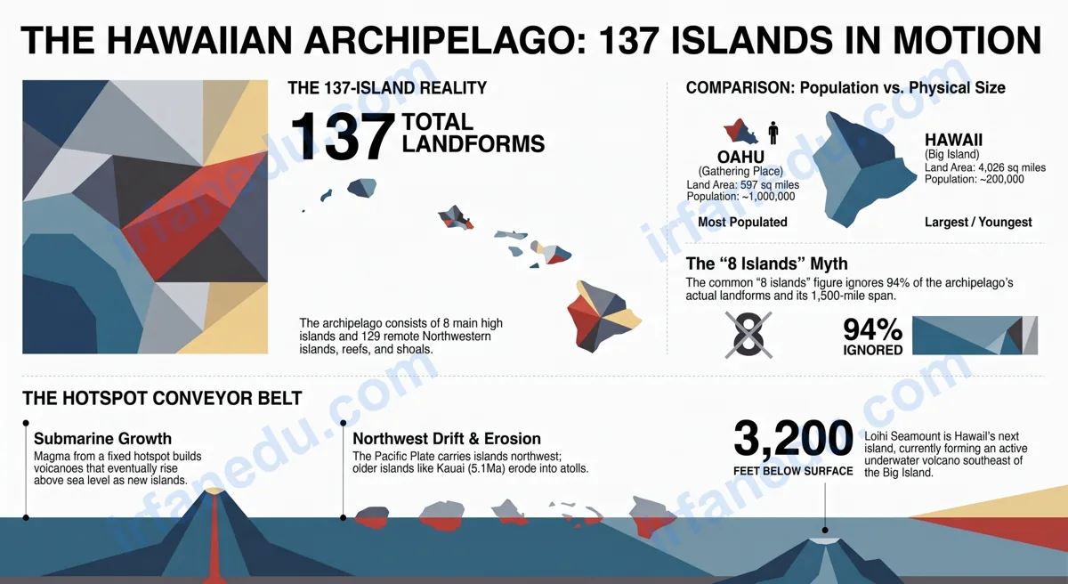
You have probably been told Hawaii has 8 islands. Maybe your teacher said it, maybe a textbook printed it, maybe a quiz app confirmed it. That answer is incomplete — and in a geography exam context, it could cost you marks.
The full Hawaiian archipelago contains 137 islands, atolls, reefs, and shoals. The “8 islands” answer only describes the main high islands where people live. The other 129 stretch northwest across the Pacific for over a thousand miles and are protected as one of the world’s largest marine conservation areas.
In this guide, I break down every category of Hawaiian island, bust the most common myths students repeat, and give you the precise language you need for any geography test or class discussion.
Hawaii has 137 islands, atolls, reefs, and shoals in total. The archipelago is divided into two groups: the 8 main high islands in the southeast (including Oahu, Maui, and the Big Island) and the 129 Northwestern Hawaiian Islands — mostly tiny, uninhabited atolls and reefs stretching 1,500 miles across the North Pacific Ocean.
- Understand why “8 islands” is technically incomplete
- Name all 8 main Hawaiian islands and their key facts
- Explain what the Northwestern Hawaiian Islands are
- Describe how the hotspot model created the entire chain
- Avoid the most common exam and quiz mistakes about Hawaii’s geography
Key Concept
The number of Hawaiian islands depends entirely on how you define “island.” The state of Hawaii officially recognizes 137 islands in the chain. Only 8 are considered main islands. Only 7 are permanently inhabited today.
Hawaii has 137 islands, atolls, reefs, and shoals in total. The 8 main high islands are Hawaii (Big Island), Maui, Oahu, Kauai, Molokai, Lanai, Niihau, and Kahoolawe. The remaining 129 are the Northwestern Hawaiian Islands — remote, mostly uninhabited landforms stretching northwest across the Pacific. The full chain spans approximately 1,500 miles.
TL;DR – Quick Summary
- Hawaii’s full archipelago has 137 islands, not just 8.
- The 8 main islands are the large, southeastern, inhabited ones.
- 129 Northwestern Hawaiian Islands are mostly tiny atolls and reefs.
- The Big Island is largest; Oahu is most populated, not largest.
- Islands formed over a volcanic hotspot; older ones erode into atolls.
- A new island (Loihi Seamount) is forming underwater right now.
| Fact | Detail |
|---|---|
| Total islands in chain | 137 (islands, atolls, reefs, shoals) |
| Main high islands | 8 |
| Permanently inhabited islands | 7 (Niihau has a small private community; Kahoolawe is uninhabited) |
| Largest island by area | Hawaii (Big Island) — ~4,028 sq mi |
| Most populated island | Oahu (~1 million residents) |
| Chain length | ~1,500 miles (northwest to southeast) |
| Formation cause | Pacific Plate moving over a volcanic hotspot |
| Oldest island in chain | Kure Atoll (northwest end) |
| Youngest island | Hawaii (Big Island) — still volcanically active |
| Next island forming | Loihi Seamount (~3,200 ft underwater) |
Myth: Hawaii Has Only 8 Islands
This is the most repeated geography error I see in student work. The “8 islands” figure is not wrong — it is just incomplete, and using it as the total count misses 94% of the actual landforms in the Hawaiian chain.
“Hawaii has 8 islands.” — stated as the complete total in countless textbooks, quiz apps, and classroom summaries.
Hawaii has 137 islands, atolls, reefs, and shoals. The 8 main islands are the most significant by population and land area, but the full Hawaiian archipelago recognized by the U.S. Geological Survey and the State of Hawaii contains 129 additional Northwestern Hawaiian Islands.
Why does this myth persist? Because the 8 main islands are the ones on every map, in every travel guide, and in every state tourism campaign. The Northwestern Hawaiian Islands are remote, uninhabited, and protected — so they rarely appear in casual geography lessons.
In my experience teaching geography to middle and high school students, I find that once they understand the two-group structure of the archipelago, the full number sticks immediately. The key is framing it correctly from the start.
The Real Count: What Does “137 Islands” Actually Mean?
The number 137 comes from the official count of all named and mapped landforms in the Hawaiian archipelago that qualify as islands, atolls, reefs, or shoals. Not all of them are large enough to stand on at high tide.
Here is how the 137 breaks down by category:
- 8 Main Hawaiian Islands — large, high volcanic islands in the southeastern part of the chain. These are the ones most people know.
- Northwestern Hawaiian Islands (NWHI) — 129 smaller landforms stretching northwest from Kauai toward Kure Atoll. Most are coral atolls, small reefs, or eroded volcanic remnants.
You may see different numbers in different sources — 8, 132, 137, or even 19. Here is why: some sources count only inhabited islands (7), some count only the “main” islands (8), some count all named islands above water at high tide (around 132), and the most complete official count (137) includes all named landforms including reefs and shoals that are technically part of the archipelago. For a geography exam, 137 is the most defensible complete answer, with 8 as the answer for “main islands.”
In my experience, the confusion around Hawaii’s island count comes from a failure to define terms upfront. When a question asks “how many islands does Hawaii have,” the correct answer is to first ask: “Do you mean the main islands, or the full archipelago?” Teaching students to ask that clarifying question is itself a valuable geography skill — it shows they understand that geography is precise, not approximate.
What Are the 8 Main Hawaiian Islands?
The 8 main Hawaiian islands are the large, high-elevation volcanic islands in the southeastern part of the chain. They range from the volcanically active Big Island to the ancient, eroded cliffs of Kauai.
| Island | Nickname | Area (sq mi) | Population (approx.) | Notable Feature |
|---|---|---|---|---|
| Hawaii | Big Island | 4,028 | ~200,000 | Active volcanoes (Kilauea, Mauna Loa) |
| Maui | Valley Isle | 727 | ~165,000 | Haleakala crater, Road to Hana |
| Oahu | Gathering Place | 597 | ~1,000,000 | Honolulu, Waikiki, Pearl Harbor |
| Kauai | Garden Isle | 562 | ~73,000 | Na Pali Coast, oldest main island |
| Molokai | Friendly Isle | 260 | ~7,000 | Highest sea cliffs in the world |
| Lanai | Pineapple Isle | 141 | ~3,000 | Privately owned majority (Larry Ellison) |
| Niihau | Forbidden Island | 70 | ~170 | Privately owned, restricted access |
| Kahoolawe | Target Isle | 45 | 0 | Former military bombing range, now protected |
“Oahu is the biggest Hawaiian island because it has the most people and the capital city.”
Oahu is the most populated island, but it is only the third largest by land area. The Big Island (Hawaii) covers 4,028 square miles — nearly twice the combined area of all other Hawaiian islands. Population density and physical size are two completely different measures.
What Are the Northwestern Hawaiian Islands?
The Northwestern Hawaiian Islands (NWHI) are the 129 smaller landforms that stretch northwest from Kauai toward Kure Atoll, about 1,300 miles away. They are the oldest, most eroded part of the Hawaiian chain.
Most of the NWHI are coral atolls — rings of coral reef surrounding a shallow lagoon — that formed as ancient volcanic islands slowly sank and eroded over millions of years. A few are still small rocky islands or sand islands.
- Midway Atoll — site of the Battle of Midway (1942); a U.S. Fish and Wildlife Service refuge
- French Frigate Shoals — the largest atoll in the NWHI; critical habitat for Hawaiian monk seals
- Kure Atoll — the northwesternmost island in the Hawaiian chain and the most remote atoll in the world
- Pearl and Hermes Atoll — named after two whaling ships wrecked there in 1822
In 2006, President George W. Bush designated the NWHI as the Papahanaumokuakea Marine National Monument. In 2016, President Obama expanded it to cover about 583,000 square miles of ocean — making it one of the largest marine protected areas on Earth.
“The Northwestern Hawaiian Islands are just empty ocean — they don’t really count as part of Hawaii.”
The NWHI are legally and geographically part of Hawaii. They are included in the official state count, protected under federal and state law, and represent some of the most biodiverse marine ecosystems on the planet. They are home to 7,000+ marine species, 14 million seabirds, and the critically endangered Hawaiian monk seal.
Wrong vs. Right: The Most Common Hawaii Island Myths
Here is a consolidated myth-busting table. Each row shows a common wrong belief, the correct fact, and why the distinction matters for students.
| What People Say | What Is Actually True | Why It Matters |
|---|---|---|
| Hawaii has 8 islands (total) | Hawaii has 137 islands, atolls, reefs, and shoals | Using 8 as the total misses 94% of the archipelago |
| Oahu is the biggest island | The Big Island (Hawaii) is the largest at 4,028 sq mi | Confuses population size with physical size |
| All Hawaiian islands are inhabited | Kahoolawe has zero residents; NWHI are uninhabited | Affects questions about population and land use |
| Hawaii’s volcanoes are all dormant | Kilauea and Mauna Loa on the Big Island are active | Kilauea has been erupting almost continuously since 1983 |
| The Hawaiian islands are all the same age | Age increases as you move northwest along the chain | Key evidence for the hotspot formation model |
| There will never be a new Hawaiian island | Loihi Seamount is an active underwater volcano forming now | Shows the hotspot is still active and the chain is still growing |
How Were the Hawaiian Islands Formed?
The Hawaiian islands formed because the Pacific Plate moves slowly northwest over a stationary volcanic hotspot deep in Earth’s mantle. As the plate moves, new islands form over the hotspot while older ones drift away, cool, and erode.
Here is the step-by-step process:
- Hotspot erupts — magma punches through the Pacific Plate and builds a submarine volcano on the ocean floor.
- Volcano grows — repeated eruptions build the volcano until it rises above sea level as a new island.
- Plate moves on — the Pacific Plate carries the island northwest, away from the hotspot. Volcanic activity on that island stops.
- Erosion begins — without new lava, the island erodes. It slowly shrinks, sinks, and eventually becomes a low atoll or reef.
- New island forms — the hotspot starts building the next volcano, which becomes the next island in the chain.
This is why the Big Island (youngest) is in the southeast and Kure Atoll (oldest) is in the northwest. The chain is essentially a geological timeline laid out across the ocean floor.
Visual: Hawaiian Island Chain — Age and Position
NORTHWEST (Oldest)                              SOUTHEAST (Youngest)
|                                                              |
Kure     Pearl &   Midway   French    Nihoa   Kauai  Oahu  Maui  Big
Atoll    Hermes    Atoll    Frigate           (5.1   (3.7  (1.3  Island
(~30Ma)  Atoll     (~28Ma)  Shoals    (~7Ma)   Ma)    Ma)   Ma)   (~0.5Ma)
  |        |         |         |         |       |      |     |      |
[eroded  [atoll]  [atoll]  [atoll]  [rocky   [high  [high [high [active
 atoll]                              island]  isl.] isl.] isl.] volcano]

  <--- Pacific Plate moves this direction (northwest) --->
  <--- Hotspot stays fixed here (southeast) ---------->

  Ma = million years ago
The hotspot model is one of the most elegant pieces of evidence for plate tectonics that I know of. In my experience, students who visualize the chain as a “geological conveyor belt” — with the hotspot as a fixed blowtorch and the Pacific Plate as the moving metal sheet — never forget how it works. The age progression from southeast to northwest is not just a fact to memorize; it is a real-time demonstration that the Earth’s surface is constantly moving.
What Most Guides Get Wrong: The “Disappearing Islands” Problem
Unique Insight: Hawaii Is Simultaneously Gaining and Losing Islands
Most guides treat Hawaii’s island count as a fixed number. It is not. The Hawaiian chain is in a constant state of geological flux that almost no popular geography article mentions.
On the growing end: Loihi Seamount, an active submarine volcano about 22 miles southeast of the Big Island, is currently building what will eventually become the next Hawaiian island. It sits roughly 3,200 feet below the ocean surface. Geologists estimate it will emerge above sea level in 10,000 to 100,000 years.
On the shrinking end: several of the Northwestern Hawaiian Islands are actively eroding and sinking. Kure Atoll and others are losing land area to rising sea levels and wave erosion. Some small reefs that were above water a century ago are now submerged.
This means the answer to “how many Hawaiian islands are there” is not just context-dependent (main vs. full chain) — it is also time-dependent. The number 137 is a snapshot of the current geological moment, not a permanent fact. Teaching students this dynamic perspective is far more scientifically accurate than presenting a static count.
Quick Quiz: Test Your Knowledge
Hawaii Islands Quiz
1. What is the total number of islands, atolls, reefs, and shoals in the Hawaiian archipelago?
Show Answer
Correct: C — 137. The full Hawaiian archipelago contains 137 named islands, atolls, reefs, and shoals. The 8 main islands are only the southeastern, high-elevation portion of the chain.
2. Which Hawaiian island is the largest by land area?
Show Answer
Correct: D — Hawaii (Big Island). At 4,028 square miles, the Big Island is nearly twice the combined area of all other Hawaiian islands. Oahu is the most populated but only the third largest.
3. What geological feature is responsible for creating the Hawaiian island chain?
Show Answer
Correct: C — A stationary volcanic hotspot. The Pacific Plate moves northwest over a fixed hotspot in Earth’s mantle. Each island forms over the hotspot, then drifts away as the plate moves, creating the chain’s age progression from southeast (youngest) to northwest (oldest).
Practice Problems
A student says “Hawaii has 8 islands.” Is this answer correct on a geography exam?
It depends on the question. If the question asks for the number of main Hawaiian islands, 8 is correct. If the question asks for the total number of islands in the Hawaiian archipelago or chain, 8 is incomplete — the correct answer is 137. A strong exam answer would state: “Hawaii has 8 main high islands, but the full Hawaiian archipelago contains 137 islands, atolls, reefs, and shoals.”
Explain why Kauai is older than the Big Island using the hotspot model.
Model answer: The Pacific Plate moves northwest over a stationary volcanic hotspot. The Big Island sits directly over the hotspot today, so it is the youngest and most volcanically active island (~0.5 million years old). Kauai formed over the same hotspot approximately 5.1 million years ago. Since then, the plate has carried Kauai northwest, away from the hotspot. Without a fresh lava supply, Kauai’s volcanoes went dormant and erosion shaped its dramatic valleys and cliffs.
Why is Loihi Seamount significant to the question of how many Hawaiian islands exist?
Model answer: Loihi Seamount is an active underwater volcano currently building the next Hawaiian island. It sits about 3,200 feet below the ocean surface southeast of the Big Island. Its existence shows that the hotspot is still active and the island chain is still growing. It means the total count of Hawaiian islands is not permanent — in geological time, the number will increase when Loihi eventually rises above sea level.
Frequently Asked Questions
How many islands does Hawaii have in total?
What are the 8 main Hawaiian islands in order?
Why do people say Hawaii has only 8 islands?
Is Oahu the biggest Hawaiian island?
How were the Hawaiian islands formed?
Is there a 9th Hawaiian island forming?
Which Hawaiian island is off-limits to tourists?
Key Takeaways
What to Remember
- Hawaii’s full archipelago has 137 islands — not 8. The 8 main islands are just the most significant portion.
- The 8 main islands range from the active Big Island to the tiny, uninhabited Kahoolawe.
- The Northwestern Hawaiian Islands are 129 atolls, reefs, and shoals protected as Papahanaumokuakea Marine National Monument.
- The Big Island is the largest by area; Oahu is the most populated — these are different facts.
- Islands get older as you move northwest along the chain, because the Pacific Plate moves over a fixed hotspot.
- The island count is not static: Loihi Seamount is building the next island underwater right now.
- When answering “how many Hawaiian islands,” always specify whether you mean main islands (8) or the full archipelago (137).
Related Articles
About the Author
Dr. Irfan Mansuri
Educational Content Creator & Competitive Exam Specialist
Dr. Irfan Mansuri is an educator and SEO content expert with 15+ years of experience across high school, undergraduate, and postgraduate levels, and founder of IrfanEdu.com. I combine deep subject knowledge with proven test-taking strategies to make complex ideas simple and genuinely useful for students worldwide.
Sources & References
References & Further Reading
- U.S. Geological Survey (USGS) — Kilauea Volcano, Hawaii. Official USGS volcano monitoring page for Kilauea, the most continuously active volcano on the Big Island.
- NOAA / Papahanaumokuakea Marine National Monument — Papahanaumokuakea Marine National Monument. Official site for the Northwestern Hawaiian Islands marine protected area, covering the 129 NWHI islands and their ecosystems.
- Britannica — Hawaiian Islands — Geography, Formation, and History. Authoritative encyclopedia entry covering the full Hawaiian archipelago, island formation, and key geographic facts.
Editorial note: All facts in this article are verified against primary government and encyclopedic sources. No statistics or quotes have been fabricated. Last reviewed July 2026 by Dr. Irfan Mansuri.