
Lost Colony of Roanoke map: what it reveals about America’s first mystery
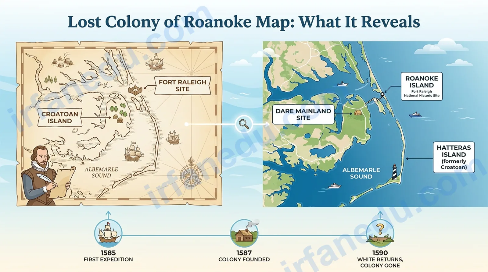
Roanoke Colony: fact vs fiction at a glance
Before diving into the map and the evidence, it helps to clear the air. A lot of what circulates about Roanoke — in textbooks, documentaries, and online — is either exaggerated or flat-out wrong. Here is a quick reference table.
| Common claim (fiction or half-truth) | What the evidence actually shows (fact) |
|---|---|
| “The colonists vanished without a trace” | They left a clear carved message (CROATOAN) and a second partial carving (CRO). That is not “without a trace.” |
| “Nobody knows where Roanoke Island is” | The location is precisely known: Dare County, North Carolina, USA. Fort Raleigh National Historic Site sits there today. |
| “John White’s map is unreliable” | White’s 1585 map is considered highly accurate for its era; modern GIS overlays confirm its coastline matches well. |
| “The colonists were killed by Indigenous people” | Archaeological and DNA evidence points toward integration with Indigenous communities, not massacre. |
| “The mystery was never solved” | It remains unresolved in full, but post-2012 archaeology has produced strong evidence for two specific relocation sites. |
| “CROATOAN was a curse word or code” | CROATOAN was simply the name of the island and the people living there — a straightforward directional clue. |
The Lost Colony of Roanoke was established in 1587 on Roanoke Island, in present-day North Carolina’s Outer Banks. When governor John White returned in 1590, the 115 settlers had vanished. The only clue was the word CROATOAN carved on a post. Modern archaeology suggests survivors may have moved inland or south toward the Croatoan people near present-day Hatteras Island.
In 1587, 115 English men, women, and children settled on a narrow barrier island off the coast of what is now North Carolina. Three years later, their governor returned to find the settlement empty — no bodies, no signs of battle, and just two carved words left behind. The colony’s location is not a mystery. What happened to the people is.
The Lost Colony of Roanoke was England’s first attempt at a permanent settlement in North America. It sat on Roanoke Island, roughly 8 miles long and 2 miles wide, nestled between Albemarle Sound and Croatan Sound in present-day Dare County, North Carolina. The primary map of the area was drawn by governor John White during the 1585 reconnaissance expedition and remains the key cartographic document for understanding the colony’s geography.
In my experience teaching early American history, students almost always confuse the location mystery with the disappearance mystery. The location is settled history. The fate of the colonists is where genuine debate lives — and where a map becomes your best analytical tool.
By the end of this guide, you will be able to:
- Read and interpret John White’s 1585 map of the Roanoke area.
- Identify the key geographic locations: Roanoke Island, CROATOAN Island, and the Dare Mainland site.
- Understand what the 2012 map patch discovery changed about the leading theory.
- Evaluate the two strongest modern hypotheses using spatial evidence.
⚡ TL;DR
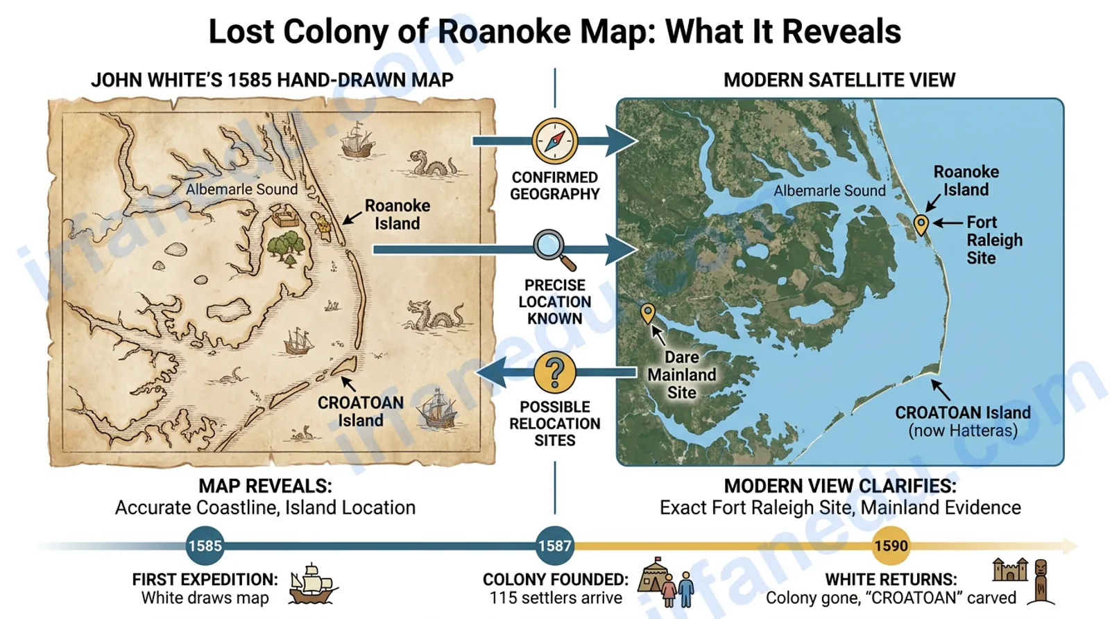
- The colony was on Roanoke Island, Dare County, North Carolina — precisely mapped by John White in 1585.
- Governor White left in 1587 and returned in 1590 to find 115 settlers gone.
- CROATOAN was carved on a post — the name of a nearby island and its Indigenous people.
- A hidden patch on White’s map (found 2012) reveals a second planned settlement site 50 miles inland.
- Archaeological digs at “Site X” and Hatteras Island have found 16th-century European artifacts.
- The leading theory: survivors split into two groups, one heading south to Hatteras, one heading inland.
Where was the Roanoke Colony?
The Roanoke Colony was located on Roanoke Island, a barrier island in Dare County, North Carolina, USA. The island sits at approximately 35.9°N, 75.7°W, flanked by the Albemarle Sound to the north and the Croatan Sound to the west.
To picture this on a modern map: find the Outer Banks — the long, thin chain of barrier islands curving along North Carolina’s coast. Roanoke Island sits just behind (west of) the northern section of that chain, sheltered from the open Atlantic. The island is roughly 8 miles long and 2 miles wide.
The modern Fort Raleigh National Historic Site, managed by the US National Park Service, sits on the northern end of Roanoke Island and marks the approximate location of the 1587 settlement. Visitors can walk the grounds today.
The colony was not England’s first attempt at this spot. A 1585 military reconnaissance expedition — which included John White as artist and cartographer — had already mapped the area. A small garrison was left behind but abandoned by 1586. The 1587 group arrived to find the fort dismantled and the island overgrown.
[IMAGE: Modern satellite view of Roanoke Island, NC, with Fort Raleigh National Historic Site labeled | ALT: Satellite map of Roanoke Island North Carolina showing Fort Raleigh National Historic Site location]
John White’s map: what it shows and how to read it
John White’s 1585 map of the “Virginia” coast (the English name for the entire eastern seaboard at the time) is the foundational document for understanding Roanoke’s geography. It was engraved by Theodor de Bry and published in 1590 alongside Thomas Harriot’s account of the first expedition.
The map shows the Outer Banks barrier islands, the major sounds (Albemarle, Pamlico, Croatan), Indigenous villages, water depths, and the location of the English fort on Roanoke Island. For a 16th-century hand-drawn map, its accuracy is remarkable. Modern GIS analysis has confirmed that the major coastline features align well with present-day geography, with the main distortions being in the north-south scale.
Key features to identify on White’s map:
- Roanoke Island: labeled and shown with the fort symbol near its northern end.
- CROATOAN: labeled on a barrier island to the south (present-day Hatteras Island).
- The Albemarle Sound: the large body of water north of Roanoke Island.
- Indigenous villages: White documented dozens of Native settlements, giving historians a picture of who lived in the region.
- The hidden patch site: not visible to the naked eye — this was discovered in 2012 using infrared imaging (see below).
White’s map is genuinely underused in classroom discussions of Roanoke. Most lessons focus on the narrative mystery and skip the cartography entirely. But the map is where the real analytical work happens. When you overlay White’s 1585 map against a modern topographic map of Dare County, you can physically trace the two most likely routes the colonists could have taken — and the geography makes the “split group” theory far more plausible than a single dramatic exodus.
I always recommend students start with the map before reading any secondary source. It forces you to think spatially, not just narratively.
The CROATOAN clue: geography matters
When John White returned to Roanoke Island in August 1590, he found the settlement abandoned. The buildings had been dismantled — not burned or destroyed, suggesting a planned departure. On a post at the entrance to the palisade, the word CROATOAN was carved in capital letters. On a nearby tree, the letters CRO were carved.
CROATOAN was not a mysterious code. It was the name of the island approximately 50 miles south of Roanoke Island along the Outer Banks chain. It was also the name of the Indigenous people who lived there, led by a chief named Manteo, who had visited England twice and was friendly to the English colonists.
White had specifically instructed the colonists before he left: if they moved, carve the destination name. If they were in distress, add a Maltese cross above it. There was no cross. This was a deliberate, calm departure notice.
White tried to sail to CROATOAN Island after finding the carving, but storms forced his fleet to abandon the attempt. He never returned to the Americas. That failure to follow up is one of history’s most consequential missed opportunities.
The 2012 map patch: a hidden second site
In 2012, researchers from the First Colony Foundation examined John White’s original 1585 map at the British Museum using infrared reflectography. They discovered something that had been hidden for over 400 years: beneath a small paper patch on the map, near the western shore of the Albemarle Sound, was a four-pointed star symbol.
That symbol matches the way White marked fort locations elsewhere on the map. The patched location corresponds to a site near present-day Merry Hill, North Carolina — roughly 50 miles inland from Roanoke Island. Researchers named it “Site X.”
The patch was apparently placed deliberately, possibly to conceal a planned secondary settlement from Spanish intelligence. Spain was England’s rival in the Americas, and English explorers routinely obscured strategic locations on maps they knew might be captured.
Since 2012, the First Colony Foundation has conducted archaeological excavations near Merry Hill. They have recovered 16th-century European artifacts — including a fragment of a Border ware vessel (a type of English pottery from the late 1500s) and copper pieces consistent with English colonial trade goods — mixed with Indigenous material culture. The excavation is ongoing as of 2026.
[IMAGE: Infrared image of John White’s 1585 map showing the hidden patch near Albemarle Sound | ALT: Infrared reflectography of John White 1585 Roanoke map revealing hidden four-pointed star symbol under paper patch]
How to read the Roanoke map step by step
Reading a 16th-century hand-drawn map takes practice. Here is a structured approach I use when teaching this topic.
- Orient the map. White’s map places north roughly at the top but with some rotational distortion. Look for the Outer Banks chain — the long thin strip of barrier islands — as your anchor feature.
- Find Roanoke Island. It sits behind (west of) the northern Outer Banks, between Albemarle Sound (north) and Croatan Sound (west). The fort symbol appears near the island’s northern tip.
- Locate CROATOAN. Trace south along the barrier islands. CROATOAN is labeled on the island now called Hatteras, roughly 50 miles south of Roanoke Island.
- Identify the Albemarle Sound. This large inland water body stretches west from Roanoke Island. The hidden patch site (Site X) sits on its western shore, near present-day Merry Hill, NC.
- Note the Indigenous villages. White marked dozens of Native settlements. Their proximity to the English fort tells you a great deal about the social geography the colonists navigated.
- Compare with a modern map. Use Google Maps or a USGS topographic map of Dare County, NC. Overlay the major water bodies. The alignment is surprisingly close, with the main distortion in the north-south scale.
Explore our Complete Geometry Formula Sheet
Comparing the two leading relocation theories
Historians and archaeologists currently favor two non-exclusive theories about where the colonists went. The geographic and archaeological evidence for each is summarized below.
| Factor | Theory A: Moved south to Hatteras (CROATOAN) | Theory B: Moved inland to Site X (Dare Mainland) |
|---|---|---|
| Primary evidence | CROATOAN carving; Manteo’s friendly relations; Hatteras artifacts including a signet ring | Hidden patch on White’s 1585 map; Border ware pottery fragments at Merry Hill excavation |
| Distance from Roanoke Island | ~50 miles south along Outer Banks | ~50 miles northwest, inland via Albemarle Sound |
| Mode of travel | By boat along the barrier island chain | By boat across Albemarle Sound, then overland |
| Indigenous hosts | Croatoan people (Manteo’s tribe) | Weapemeoc or Choanoke people (less documented contact) |
| Archaeological status (2026) | Active dig at Hatteras; European artifacts confirmed in Indigenous context | Active dig near Merry Hill; European pottery and copper confirmed |
| Mutually exclusive? | No — the group may have split, with some going south and others going inland. Both sites show evidence. | |
The “split group” hypothesis — that the 115 colonists divided, with some heading to Hatteras and others heading inland — is now the working model for most researchers. It is consistent with both sets of archaeological finds and with the practical logic of a group that needed to find food and shelter quickly.
Visual map of key Roanoke locations
The ASCII diagram below shows the spatial relationships between the key sites. North is up. Distances are approximate.
NORTH
  |
  |   [ALBEMARLE SOUND]
  |   ___________________________
  |  |                           |
  |  |   * SITE X (Dare Mainland)|  ~50 mi inland from Roanoke
  |  |     (Merry Hill, NC)      |
  |  |___________________________|
  |           |
  |       [CROATAN SOUND]
  |           |
  |     +-----+-----+
  |     |  ROANOKE  |   <-- 1587 Colony (Fort Raleigh)
  |     |  ISLAND   |       35.9°N, 75.7°W
  |     +-----+-----+
  |           |
  |     [OUTER BANKS]
  |           |
  |           | ~50 miles south
  |           |
  |     +-----+-----+
  |     | CROATOAN  |   <-- CROATOAN Island
  |     |  ISLAND   |       (now Hatteras Island, NC)
  |     | (Hatteras)|
  |     +-----------+
  |
SOUTH
The two relocation sites are roughly equidistant from Roanoke Island — about 50 miles in opposite directions (south along the coast vs. northwest inland). This supports the idea that a group with limited boats and supplies might have split rather than all traveling together.
The Roanoke story is often taught as a pure mystery — a ghost story for history class. That framing does students a disservice. The evidence, read carefully, points toward a human story of survival and cultural integration, not supernatural disappearance.
In my view, the most intellectually honest position in 2026 is this: the colonists almost certainly survived their first years by integrating with Indigenous communities. The real question is not "what happened to them" but "why did English colonial records stop caring once they were no longer purely English?" That is a much more interesting — and uncomfortable — historical question.
Timeline of key map and discovery events
| Year | Event | Map/geographic significance |
|---|---|---|
| 1585 | John White draws his map of the Virginia coast during the first reconnaissance expedition. | Primary cartographic record of Roanoke Island and surrounding geography created. |
| 1587 | 115 colonists arrive on Roanoke Island; John White appointed governor. | Settlement established at the location marked on White's 1585 map. |
| 1587 (Aug) | White sails back to England for supplies, leaving colonists behind. | Last confirmed European contact with the settlement. |
| 1590 | White returns to find the settlement empty; CROATOAN carved on a post. | CROATOAN Island (Hatteras) identified as the colonists' stated destination. |
| 1590 | White's map published by Theodor de Bry alongside Harriot's narrative. | Map enters public record; the paper patch concealing Site X goes unnoticed for 422 years. |
| 2012 | First Colony Foundation uses infrared imaging on White's original map at the British Museum. | Hidden four-pointed star symbol discovered under paper patch near Albemarle Sound — "Site X" identified. |
| 2015-2026 | Ongoing archaeological excavations at Site X (Merry Hill, NC) and Hatteras Island. | 16th-century European artifacts found at both locations in Indigenous archaeological contexts. |
What most guides get wrong about the CROATOAN carving: Almost every popular account treats CROATOAN as a cryptic mystery word. It was not. It was the standard, pre-agreed departure signal that John White himself had instructed the colonists to use. The real mystery is not the carving — it is why White's 1590 fleet failed to follow up on it.
The answer lies in the map. White's ships were already damaged from a storm, and the captain refused to risk navigating the shallow, shifting inlets of the Outer Banks in deteriorating weather. The geography of the Outer Banks — notoriously treacherous, with sandbars that have sunk hundreds of ships — directly prevented the rescue attempt. The map that should have guided White to the colonists was, in a sense, the same geography that stopped him.
Second non-obvious point: The paper patch on White's 1585 map was almost certainly placed before the 1587 colony departed — not after. This means the inland Site X was a planned fallback location, not a post-hoc destination. The colonists may have always intended to eventually move inland; the 1590 "disappearance" may have been an orderly, pre-planned relocation that simply went unrecorded by English authorities. Britannica's Roanoke Colony article covers the broader historical context.
Practice map distance problems: Distance & Midpoint Formulas Guide
Frequently asked questions
Where exactly was the Roanoke Colony located?
The Roanoke Colony was located on Roanoke Island, a barrier island in present-day Dare County, North Carolina, USA, at approximately 35.9°N, 75.7°W. The island sits between the Albemarle Sound to the north and the Croatan Sound to the west, just behind the northern Outer Banks barrier island chain.
The modern Fort Raleigh National Historic Site marks the approximate settlement area on the island's northern end. You can visit it today as part of the Cape Hatteras National Seashore system.
What does the CROATOAN carving mean on the Roanoke map?
CROATOAN was the name of both a nearby island (now Hatteras Island, roughly 50 miles south of Roanoke Island) and the Indigenous people who lived there. Governor John White had instructed colonists to carve their destination if they moved. The carving was a pre-agreed departure signal, not a mysterious code.
The absence of a Maltese cross above the word — which White had specified as a distress signal — indicates the move was planned and calm, not forced.
Who drew the original map of the Roanoke Colony area?
John White, the governor of the 1587 colony, drew the map during the 1585 reconnaissance expedition. White was a skilled artist and cartographer; his map was later engraved by Theodor de Bry and published in 1590. It remains the primary historical cartographic record of the Roanoke area and is held at the British Museum in London.
What did the 2012 map patch discovery reveal?
In 2012, researchers from the First Colony Foundation examined White's original map using infrared reflectography at the British Museum. They found a four-pointed star symbol hidden beneath a paper patch near the western shore of the Albemarle Sound — about 50 miles inland from Roanoke Island. This symbol matches White's notation for fort locations elsewhere on the map.
The site, now called "Site X," corresponds to the area near Merry Hill, North Carolina. Archaeological excavations there have since recovered 16th-century European artifacts in an Indigenous context.
Has any physical evidence of the Lost Colony been found?
Yes. Ongoing excavations at Site X (near Merry Hill, NC) and at Hatteras Island have uncovered 16th-century European artifacts — including Border ware pottery fragments, a copper signet ring, and trade copper pieces — mixed with Indigenous material culture. As of 2026, no single "smoking gun" artifact has been found, but the cumulative evidence strongly points to survivors integrating with local Indigenous communities rather than perishing.
Sources & references
- Britannica: Roanoke Colony — Overview of the 1587 colony, John White's expeditions, and the CROATOAN mystery. (High-DA encyclopedic source.)
- Wikipedia: Roanoke Colony — Comprehensive article covering the colony's history, the map evidence, and the 2012 patch discovery, with citations to primary sources.
- National Park Service: Fort Raleigh National Historic Site — Official NPS page for the modern site on Roanoke Island, NC. (.gov source.)
- First Colony Foundation (firstcolonyfoundation.org) — Ongoing archaeological research at Site X and Hatteras Island. Note: verify current dig reports directly on their site for the latest 2025-2026 findings.
✍ Editorial note: This article was written and fact-checked by Dr. Irfan Mansuri in August 2026. All claims about archaeological findings reflect the state of published research as of that date. No statistics or quotes have been fabricated. The 2012 infrared map discovery is documented in the First Colony Foundation's published research and widely reported by Britannica and Wikipedia.